By Deborah Bowers
State Highway officials revealed new proposals April 6 for addressing safety concerns along MD 24 through Rocks State Park. A new plan would save the scenic roadway and address streambank erosion along Deer Creek instead, the approach urged by the community group Save the Rocks. The original plans for two sections of the road called for blasting rocks to move the road away from the stream.
Highway officials outlined their new plans before the MD 24 advisory committee appointed last year by County Councilman Chad Shrodes and County Executive David Craig. It was the first meeting of that group since last June. Since then, SHA has conducted erosion rate tests along the Deer Creek. SHA told the group, and a number of other interested persons who attended, that borings taken in Section A, which runs between the Rapids Area Parking Lot and the bridge that carries MD 24 over Deer Creek, revealed some unstable conditions beneath the surface of the road. However, they confirmed that moving the road, as proposed under the first plan, would likely be only a temporary fix for those problems.
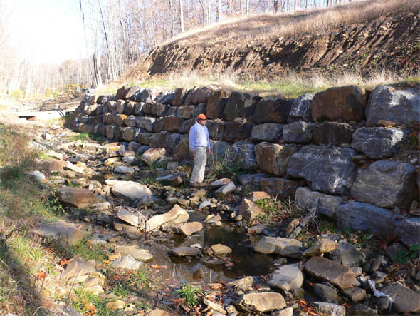
“We would like to go in and do this job once and not have to come back in 30 years,” said Kirk McClelland, director of the Office of Highway Development for SHA. McClelland said the new proposal is to work in the stream to rebuild the streambank by stacking large cut stones to form two sections of wall in the south bank of Deer Creek. The first section would be between the MD 24 bridge and the Rapids Area Parking Lot, and the second section would be built into the curve where the stream begins to flow away from the road, just south of the same parking lot. The stone work is referred to as imbricated stone.
McClelland said the new plan depends on permits being approved by the U.S. Army Corps of Engineers, which reviews all work in U.S. streams under the 1972 Clean Water Act. Joseph DaVia, from the Baltimore District of the USACE, attended the meeting.
In Dec. 2009 the SHA revealed plans to blast rock outcroppings and boulders and move MD 24 up to 20 feet into the steep hill along the west side of two sections of the two lane road. That plan was soundly rejected by the community in early 2010.
The second section, Section G, is just south of Sharon Road and includes another rock face, a private 19th century iron bridge, a Ma and Pa Railroad retaining wall that abuts the road and a private home that would be demolished under the original SHA plan. Under that plan, a high retaining wall would be constructed and up to three acres would be affected.
A second plan, revealed at the meeting, would be to construct a 15-foot high concrete wall in Deer Creek, running up to a quarter-mile long, along the side of MD 24. Neither plan was received favorably by the group, which urged SHA to study the possibility of another option. One option discussed was the potential of widening the streambed to alleviate the velocity and pressure on the streambank adjacent to the road. SHA officials said they would study that technique and search for other potential solutions.
Save the Rocks founders Deborah Bowers, Brian Goodman and Deborah Coomes said they believed a better solution for Section G could be developed that would not so significantly alter what Bowers called “the gateway to Rocks State Park.” They said they favored the imbricated stone wall plan for Section A, but indicated the group will further explore the site and wants more details before construction begins.

An imbricated rock wall constructed in western Maryland in the fall of 2009 by Ecotone Inc. of Jarrettsville. The photo was taken fall of 2010. The stream, which holds a native population of brook trout, was located at the toe of a huge hillside face prior to construction. Ecotone altered the channel alignment to make room for the wall and only had to build the wall to about 8-10’, leaving a bench between the wall and the stream. Scott McGill, a stream restoration specialist and principal with Ecotone and member of Save the Rocks, said this project and photo may provide an idea of what an imbricated wall on Deer Creek might look like.


well done Debbie…
Agreed. There has to a better way.It sound like a combination of the inbriction and the widenening of the bed would work. My question to that is how wide is too wide before you begin to have flow issues. Some of the areas are already relatively shallow would widening affect these areas?
It’s a classic lose-lose situation:
– To leave Deer Creek untouched means blasting away as much as 20 feet of the historically and culturally significant rock outcroppings that give the are its name.
– To preserve the rocks as they are today means erecting a 15-foot tall concrete wall for a quarter-mile inside the bank of Deer Creek.
Are there other alternatives?
That’s what we’re asking and looking into.
Any creative solutions would be greatly appreciated.